
Take yourself hiking near Los Angeles
Want to go hiking near Los Angeles? Fortunately, there are lots of exciting trails. Check out this list and start exploring L.A.’s natural be…


One of the best outdoor activities to enjoy while living in Los Angeles is hiking. With many trails located throughout the city, you’re bound to find a spot you love. Hiking near Los Angeles draws in thousands of residents and tourists every year. And it’s no wonder why. With sunny and mild weather year-round, hiking makes for great exercise.

Lots of popular hikes are near the neighborhoods of Hollywood and West Hollywood. So, if you’re a hiking enthusiast and want to discover some awesome trails right in your backyard, you should seriously consider moving into a Blueground apartment! They are all fully furnished and completely equipped. It’s the perfect place to stay for a month, a year, or even longer. Immediately after booking your new home, you’ll have access to the Guest App, which lets you schedule cleaning, request maintenance, and read up on your neighborhood right from your smartphone.
Runyon Canyon Trail
Neighborhood: West Hollywood
One of the most infamous hiking trails you’ll hear about while living in Los Angeles is Runyon Canyon. The base of the trail is in West Hollywood and it’s a 2.6-mile round-trip loop. At the top, you’ll see sweeping views of the entire city. Due to its popularity, there is a good amount of foot traffic, including many dogs with their owners. The hike is moderately difficult with a peak elevation of 764 feet. Runyon Canyon trail is open year-round and is frequently used by hikers, walkers, trail runners, and nature lovers. If you have a dog, this is a great trail given the generous number of off-leash areas. Give yourself plenty of time to find parking, as the only spots available are on the street.
- The distance of the hike: 2.6 miles
- Peak elevation: 764 feet
- Type of route: Loop
Griffith Observatory
Neighborhood: Little Armenia
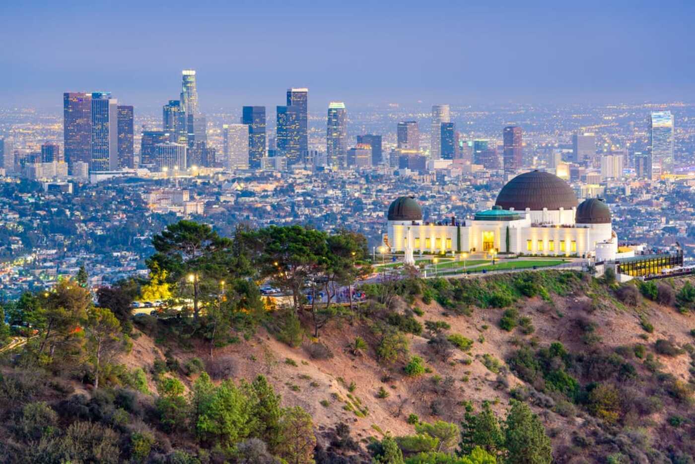
Hiking near Los Angeles is fun when you get to explore tourist destinations like the Griffith Observatory. It provides hikers with a bird’s eye view of the Los Angeles Basin. To get there you can take the West Observatory Loop trail. The distance is a short 2.5-mile walk with a few hundred feet of elevation. Although the trail is often crowded, the views at the top make the hike up there totally worth it. Dogs are allowed on the trail as long as they stay on a leash. Also, while you’re there, if you want to go inside the Observatory it’s free. Just keep in mind that it is closed on Mondays.
- The distance of the hike: 2.5 miles
- Peak elevation: 613 feet
- Type of route: Loop
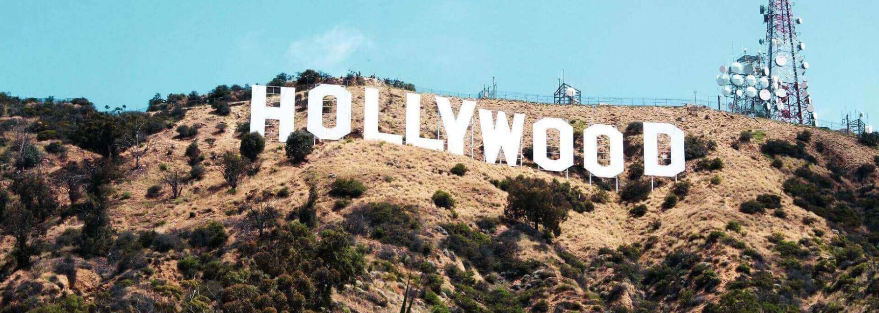
Hollywood Sign
Neighborhood: Hollywood
One of the first things new residents of L.A. do is visit the Hollywood sign. Rather than driving to see it, you can take a hike and get much closer. The Brush Canyon Trail, which starts near Canyon Drive, offers a breathtaking view. Since the trail begins right outside of Griffith Park, you can leave your car at one of their designated parking areas. This trail is about six miles in length and the difficulty level is moderate. As with many other trails, the Brush Canyon Trail is open all year long. When you reach the top, your reward is seeing a 360-degree view from behind the Hollywood sign.
- The distance of the hike: 6 miles
- Peak elevation: 1,050 feet
- Type of route: Up and back
Cahuenga Peak/Wisdom Tree Loop
Neighborhood: Griffith Park

Cahuenga Peak/Wisdom Tree Loop is a difficult hike and reaches a maximum elevation of 1,368 feet. The trail itself is steep and rocky, but in the springtime, there are beautiful wildflowers, clear blue skies, and greenery all around. For this trail, it’s recommended to wear comfortable shoes with traction because the walk down can be slippery. It’s a good trail for your cardiovascular health as the trip to the top is all uphill. Even so, hikers say that the views and friendly nature of the other hikers make the difficulty of the hike worthwhile. As you arrive near the trail, there’s convenient parking on Lake Hollywood Drive.
- The distance of the hike: 3.7 miles
- Peak elevation: 1,368 feet
- Type of route: Loop
Fryman Canyon Trail
Neighborhood: Studio City, West Hollywood Hills
In the Studio City neighborhood, slightly north of West Hollywood is the Fryman Canyon Trail. The trail is a complete loop that takes you on a 3.3-mile round-trip hike. Part of the trail has pavement, but the other parts that don’t are still well-maintained. The trail is wide enough to allow for an easy flow of people on both sides. There are lots of trees, wildflowers, and a peaceful zen vibe. This trail is not as crowded as some of the other, more well-known ones. Furthermore, most people are walking alone, with friends, lovers, or their pups.
- The distance of the hike: 3.3 miles
- Peak elevation: 695 feet
- Type of route: Loop
Temescal Canyon Trail
Neighborhood: Pacific Palisades

Temescal Canyon Trail is in West Los Angeles, only a few miles north of Santa Monica. It’s a 2.9-mile loop that’s considered moderately difficult. One of the best parts of this hike is the stunning waterfall. Other features include ocean views and lots of wildlife. Besides the cardio benefits, and enjoying time in nature, people also come here to bird watch. There are some loose rocks along the trail and some steep climbs, so wear good hiking boots. It costs $10 to park and unfortunately, dogs are not allowed on this trail.
- The distance of the hike: 2.9 miles
- Peak elevation: 875 feet
- Type of route: Loop
Silver Lake Reservoir Trail
Neighborhood: Silver Lake
When you’re pressed for time and want to take an easy, relaxing, and peaceful stroll, Silver Lake Reservoir Trail is your spot. It’s a flat, paved surface that makes a 2.2-mile loop around the reservoir. People come here to read, hang out, meditate, walk or jog. With the convenience of being close to Downtown, you can get here without spending a ton of time in traffic.
- The distance of the hike: 2.2 miles
- Peak elevation: 108 feet
- Type of route: Loop
Related Stories


